

Woodland for sale
Key information
Property description & features
- Tenure: Freehold
- Stunning location with views down the Monnow Valley
- Ideally located close to Hay-on-Wye
- Natural water source via stream
- Belt of established broadleaved woodland
- Open ground for tree planting
- 5.25 acres
- No public rights of way
- Close to the black mountains
- Can be enjoyed with friends and family
Summary:
A picturesque meadow in the foothills of The Black Mountains which combines open land suitable for planting, a belt of woodland and a stream.
Description:
Mount Meadow lies in the foothills of The Black Mountains, just a short drive from Hay-on-Wye near the England / Wales border. The meadow, along with the surrounding area, is characterised by the sweeping valleys which are formed by the peaks of the Brecon Beacons. The Black Hill, which creates a dramatic backrop to the land, is in fact the one peak which protrudes into the county of Herefordshire, with the other peaks falling on the Welsh side of the border. Mount Meadow effectively occupies the eastern side of The Black Hill, with the contours of the land falling away to the north and the east down into the Monnow Valley. Fine views down the valley can be enjoyed from the meadow.
One enters the meadow in the south east corner, just a few metres from the main entrance gate, via a stoned track. The hardstanding extends on to the meadow enabling a solid base for vehicular parking. This southern section of the land is the highest point and the place at which the best views can be enjoyed from. Looking across the valley, swathes of woodland adorn the hills creating a classical rural scene. The southern boundary is lined with trees, creating a strong boundary between the land and the quiet lane beyond the boundary. The lane itself is a dead end (due to the topography of the hill which lies beyond it to the west), with the entrance to the meadow falling almost at the end of it, meaning there is almost no other vehicular use of it. The meadow really has an 'end of the world' feel.
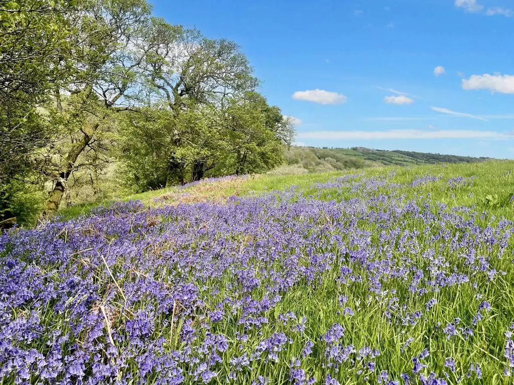
Walking along the southern boudnary one reaches the south west corner where a charming stream can be found taking water from the higher ground down towards the valley floor, where it eventually feeds into the River Monnow. A section of this stream falls within full ownership of the meadow, with a fence crossing the watercourse to show where it crosses over into the ownership of the adjoining land to the west. Following the stream north, one enters into the woodland belt which embraces the meadow along its western flank. Broadleaved species populate the bank as it drops away into the valley, with the floor alive with bluebells in the spring. The fence which crosses the stream continues through the woodland demarcating the boundary. At the nothern end of the woodland belt, the land levels out on to flatter ground where open glades can be found. The trees continue along the northern edge of the meadow, with the northern boundary itself marked with a line of field stakes which move through the woodland and along the edge of the open land. The western edge of the land is formed by an established hedgerow.
The meadow would appeal to those who are looking for a combination of habitats, including plenty of space to plant trees to create new woodland. The volume of trees already standing on the meadow would happily colonise the open land for those in favour of rewilding the land using the power of nature to drive its diversification. For those interested in actively planting trees there are grants available. The land has a very rural feel and there are no public rights of way across it. The aspect of the land, with views down and across the valley is a real feature of it. The addition of access to a natural source of water rounds off this well balanced meadow.
The surrounding area, both on the English and Welsh sides of the border is renowned for its natural beauty and extensive walking routes. The Cat's Back circular route is within walking distance of the meadow. The highly rated Bulls Head Pub is just a short walk down the lane, where fantastic food, drink and overnight rooms are available.
The purchasers of the meadow will be asked to enter into a covenant to ensure the quiet and peaceful enjoyment of adjoining woodlands and meadows.
Directions:
In terms of finding the meadow, when entering Craswall from the South (from either Longtown or Newton St Margarets direction), keep heading due north towards the HR2 0PN postcode. Follow the main road until you approach The Bulls Head Pub on your right hand side. Here, as opposed to turning 90 degrees to the right around the corner of the pub, take the lane straight ahead of you. There will be a phone box and letter box on your left hand side (opposite the pub). Follow this lane for about 1km at which point you will find the main entrance gate for the land on your right hand side, marked with a Woodlands sign. It is the next gate on the right hand side after the entrance to Old College House (which will also be on your right).
If entering Craswall from the North (Hay-on-Wye), turn right into the lane at The Bulls Head pub when the main road sweeps around the corner of the pub to the left. Again, look out for the phone box and mail box in the wall.
Once at the main entrance, park in the little pull-in opposite the gate, carefully climb the gate and Mount Meadow will be immediately on your left hand side on the other side of the hedgerow.
Click here for the Google Maps Main Gate Location, enter your own postcode (the location coordinates are already entered) and click on the "Directions" box. This will take you to the roadside gate where you can park.
Satnav: the postcode HR2 0PN is the nearest to the main entrance where you can park. However, this postcode will take you to the middle of Craswall, near The Bulls Head, not the exact locatioin of the gate.
Coordinates for satnav are: 52.019790 -3.066723 for the main entrance.
What3Words Reference: ///playfully.sweep.different
Property information from this agent
Places of interest
Tree Planting Land, Meadows & Fields - England & Wales
19 Half Moon Lane, Herne Hill London SE24 9JU
See more properties like this:
*DISCLAIMER
Property reference MountMeadow. The information displayed about this property comprises a property advertisement. OnTheMarket.com makes no warranty as to the accuracy or completeness of the advertisement or any linked or associated information, and OnTheMarket.com has no control over the content provided by the agent or developer. This property advertisement does not constitute property particulars. The information is provided and maintained by Tree Planting Land, Meadows & Fields - England & Wales.
OnTheMarket may have applied supplementary data to this property listing, including:
Broadband availability and predicted speed
Broadband speed is measured in megabits per second, with the number returned showing how fast the connection is. Each reading is based on the highest predicted speed of any major broadband network for services that deliver the download speeds. The following are the different readings that we may display:
Basic: Up to 30 Mbit/s
Super-fast: Between 30 Mbit/s and 300 Mbit/s
Ultra-fast: Over 300 Mbit/s
The data is updated three times a year. The checker results are predictions and should not be regarded as guaranteed. For more information, see: https://checker.ofcom.org.uk/en-gb/about-checker#Answer_0_2
Mobile phone signal availability and predicted strength
Mobile signal predictions are provided by the four UK mobile network operators: EE, O2, Three and Vodafone. Predictions can vary significantly from the coverage you may actually experience as a result of local factors (especially terrain). Ofcom has tested the actual coverage provided in various locations around the UK to help ensure that these predictions are reasonable. The values shown against a property can be broken down as follows:
Clear: No bars, no signal predicted
Red: One bar, reliable signal unlikely
Amber: Two bars, may experience problems with connectivity
Green: Three bars, likely to have good coverage and receive a data rate to support basic web services
Enhanced: Full bars, likely to have good coverage indoors and to receive an enhanced data rate to support multimedia services
Energy Performance data and Internal floor area
Any supplementary data should not be relied upon as forming part of any property particulars and OnTheMarket cannot be held responsible for any incorrectness in this data. See here for more information.