

Land
Premium display
Under offer
Land
2,831,403 sq ft / 263,046 sq m

Key information
Tenure: Freehold
Council tax: Ask agent
Features and description
- Under offer
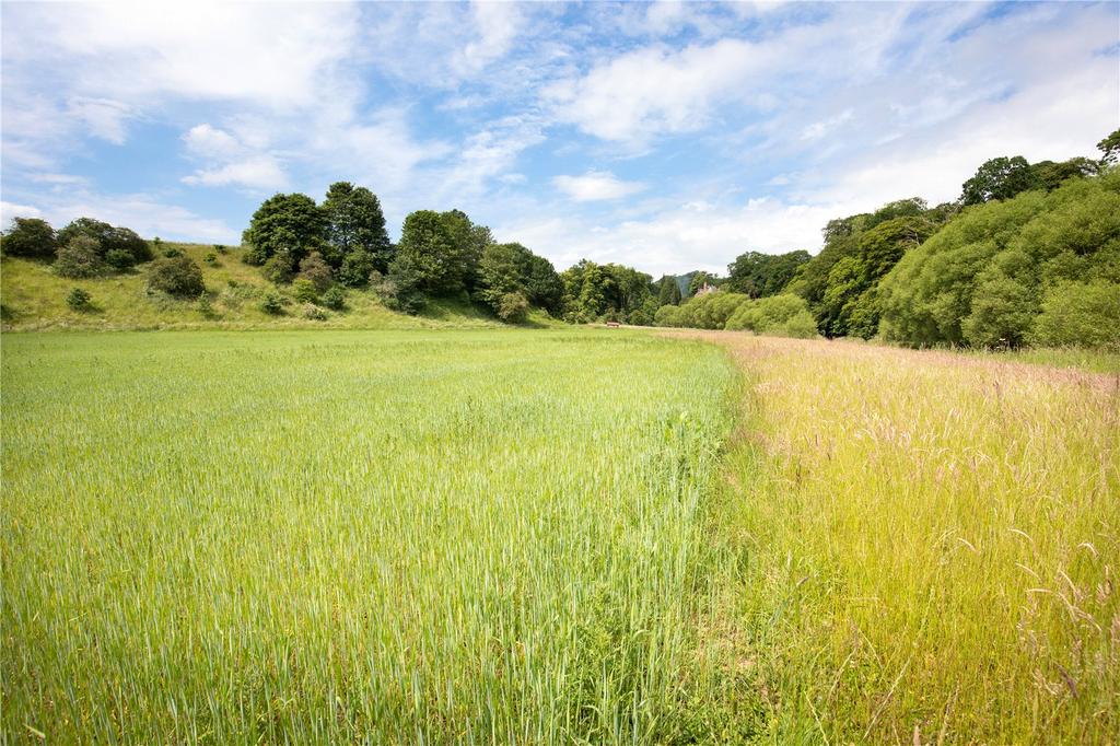
- 37 acres arable
- 7 acres pasture and open woodland
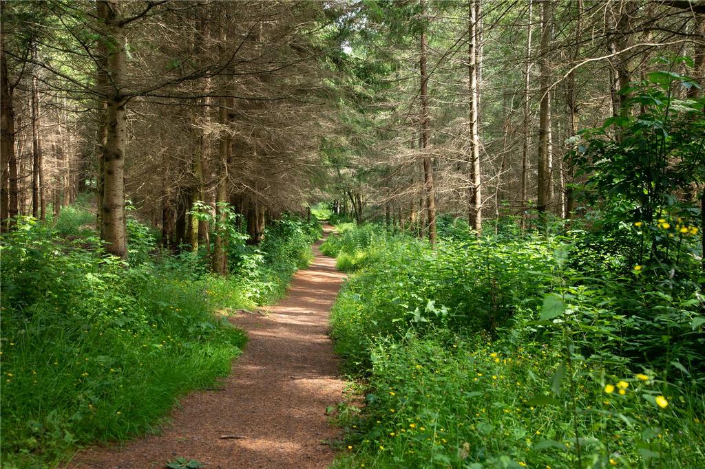
- 16 acres mixed woodland
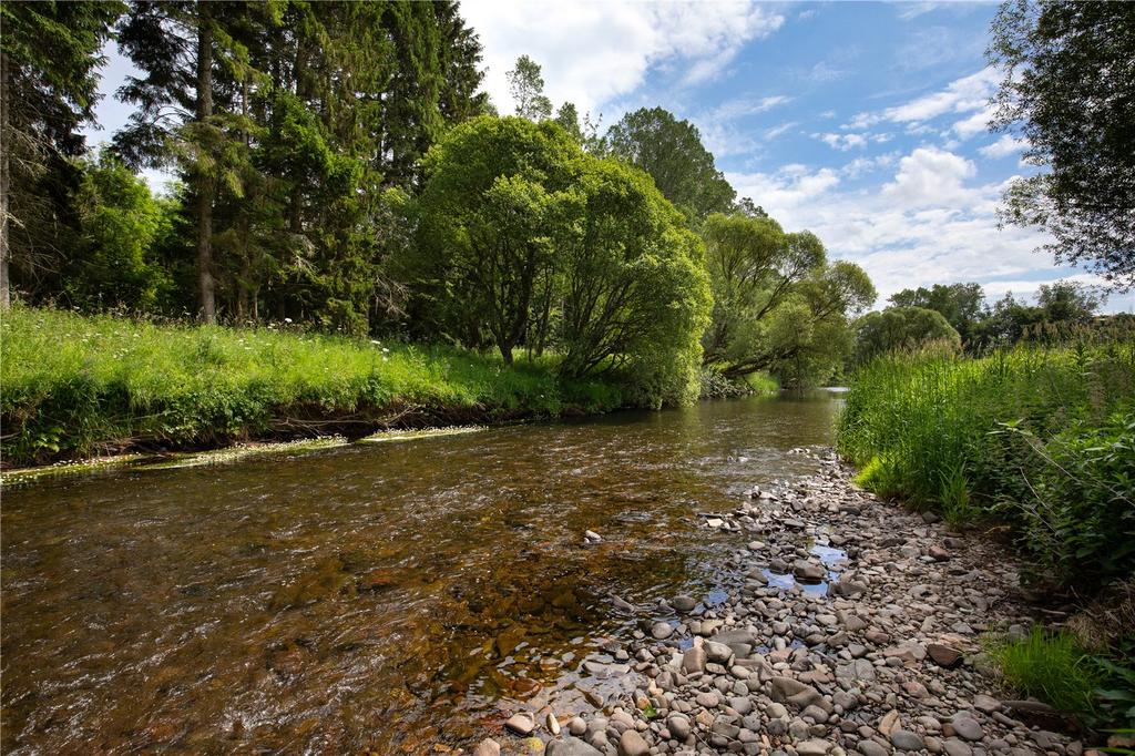
- 600 metres of river bank
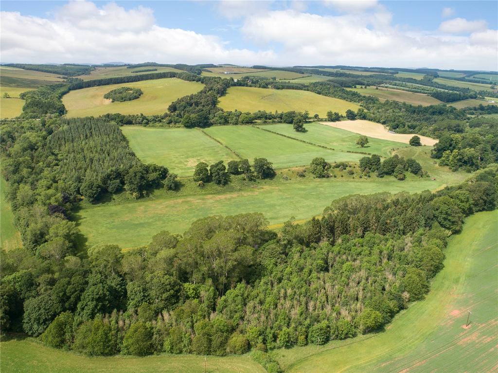
- About 65 acres in total
UNDER OFFER
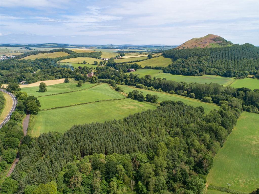
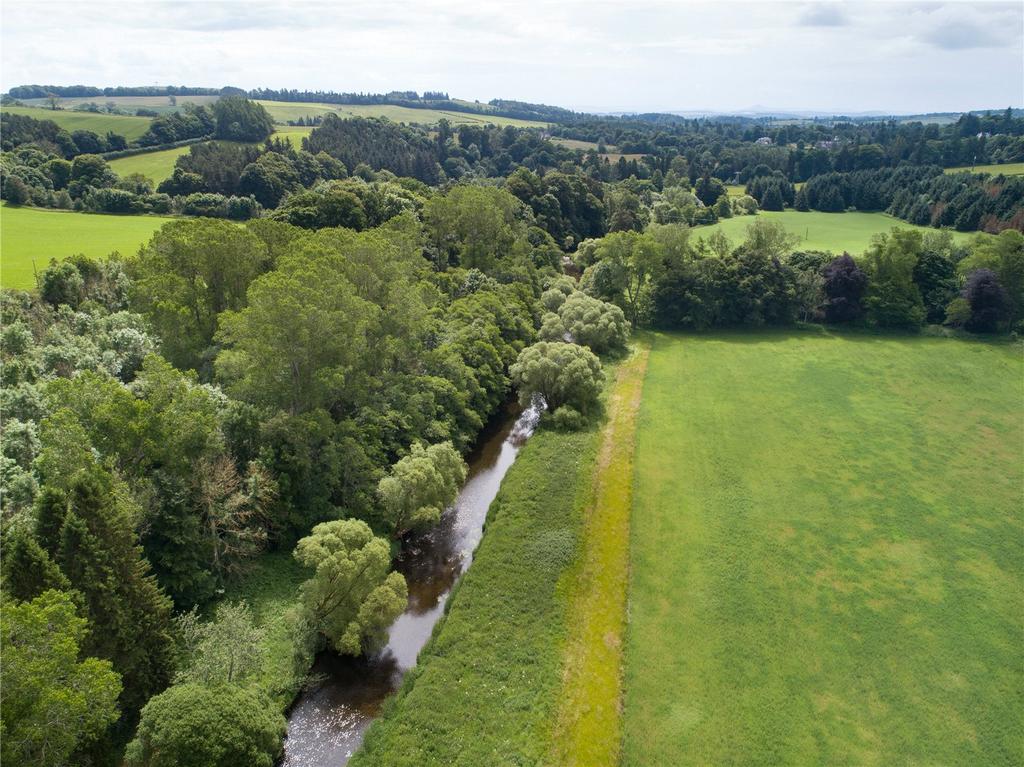
An attractive parcel of land on the Leader Water
Description
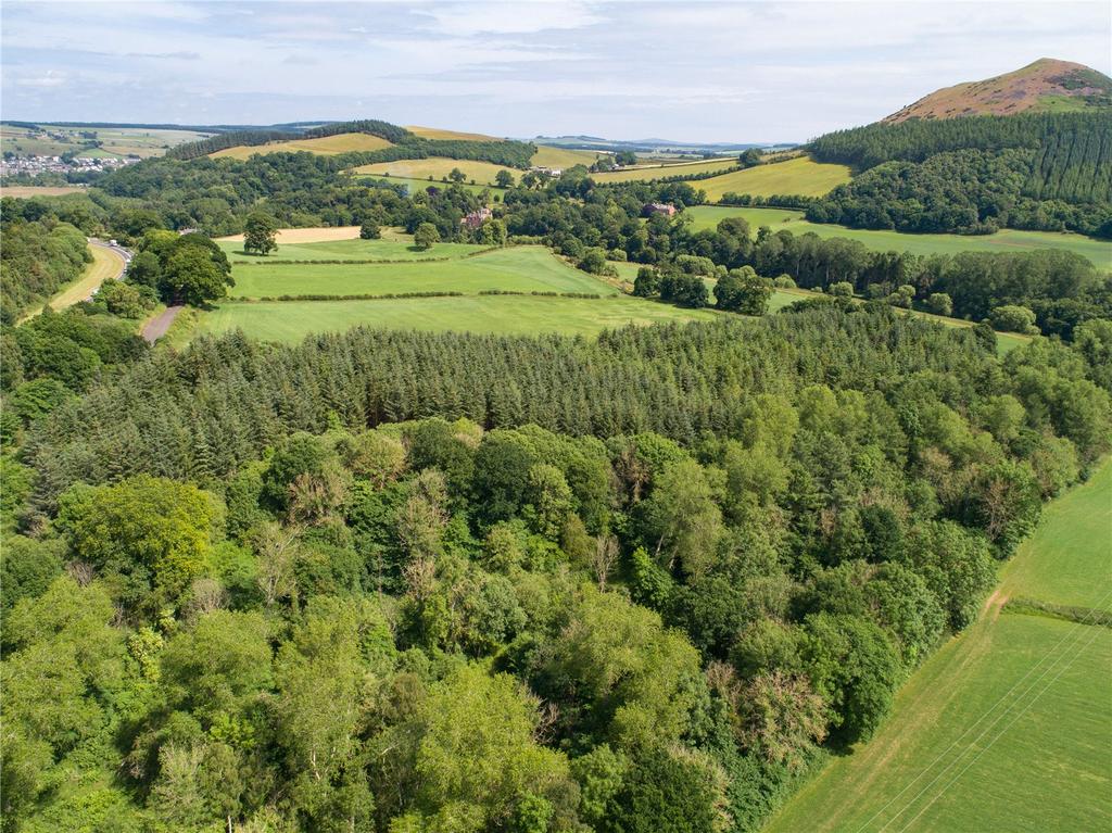
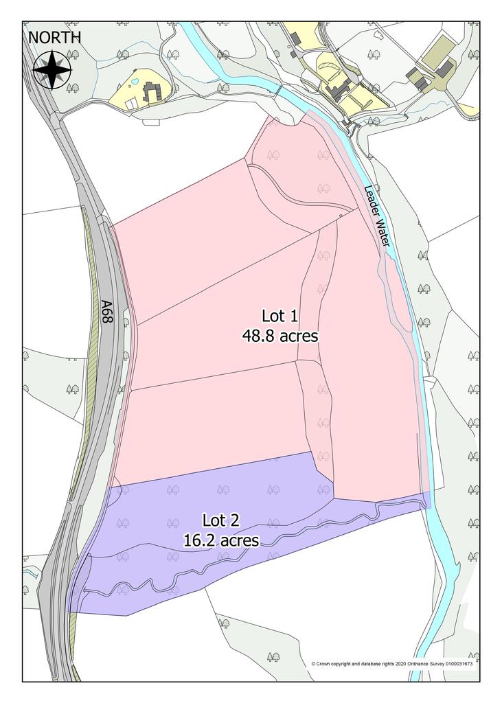
Sorrowlessfield extends to about 65 acres in total and is contained within a single parcel with the Leader Water flowing along the eastern boundary. The land rises from 90m to 130m above sea level and has a southeasterly aspect. It is mainly classified by the James Hutton Institute for Soil Research as class 3(2) with an area of class 4(1) running down the eastern side. The fields and woodland are accessed off the former A68 road which is no longer a public road but provides good access for farm machinery. The land forms part of a larger farm and is currently managed under the terms of an Agri-Environmental Climate Scheme (AECS) which ends in March 2022. It is offered for sale as a whole or in two lots as follows:
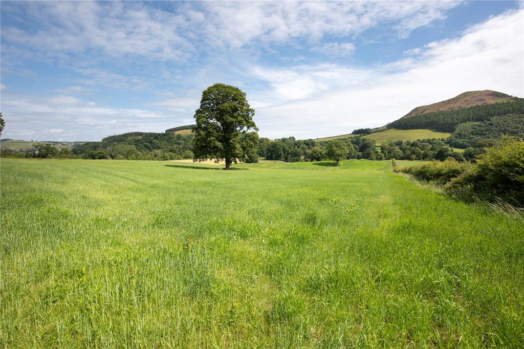
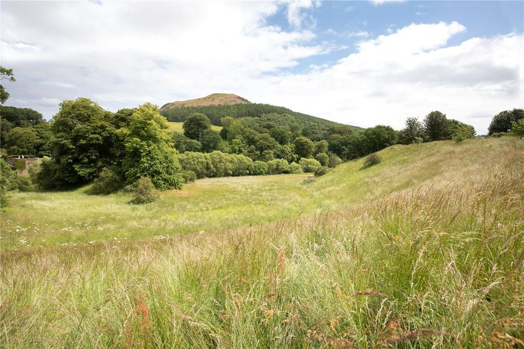
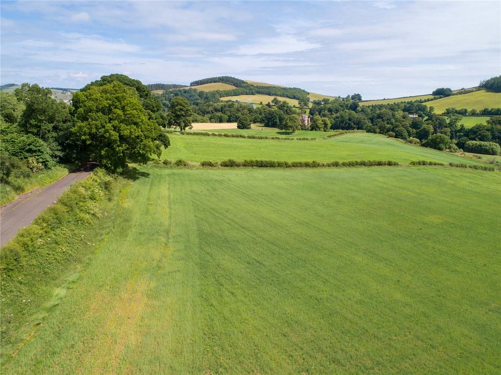
Lot 1 comprises four arable fields extending to about 37.6 acres in total and about 7.3 acres of open woodland and pasture. Prior to entering into the AECS the arable land was primarily cropped with winter barley. The pasture is not grazed at present but an area towards the northern end could be fenced and would provide sheltered grazing for stock or horses as could the arable fields. The gently flowing Leader Water could offer the keen fisherman the opportunity to catch the occasional trout.
Lot 2 comprises a small woodland extending to about 16.2 acres known as Packman’s Wood. It runs from the banks of the river westwards to the old A68 and is intersected by the Packman’s Burn which flows through a steep sided dean before entering the Leader Water. Lot 2 can be broadly split between 6 acres of commercial conifers with the remainder being primarily mixed broadleaves.
Location
The land at Sorrowlessfield possesses a most attractive position on the banks of the Leader Water in the Scottish Borders. The river flows southwards before joining the River Tweed just one mile downstream from the property. This picturesque landscape is defined by rolling farmland and beautiful copses and established woodland. The village of Earlston lies one mile to the north and the land sits to the east of the A68 public road. The area is served by an active machinery ring and a livestock market at Newton St Boswells (3.5 miles).
Acreage: 65 Acres
Directions
From the north, take the A68 south to Earlston. Pass through Earlston and continue for about 1 mile. The access point to the land lies along this road on the left.
From the south, take the A68 north towards St Boswells. Continue through St Boswells for about 4.5 miles. The access point to the land lies along this road on the right. The nearest postcode is TD6 6AQ.
Additional Info
VIEWING: Strictly by appointment with Savills Edinburgh Office. Given the potential hazards of a working farm, we request you take care when viewing the property.
ENTRY AND POSSESSION: Entry and possession will be given in March 2022 or earlier by arrangement.
ENVIRONMENTAL DESIGNATIONS: The land at Sorrowlessfield falls within the Lothian and Borders Nitrate Vulnerable Zone (NVZ) and the Eildon and Leaderfoot National Scenic Area. The Leader Water falls within the River Tweed Special Area of Conservation.
SERVITUDE RIGHTS, BURDENS, WAYLEAVES AND STATUTORY PUBLIC AND OTHER ACCESS RIGHTS: The property is sold subject to and with the benefit of all existing servitude and wayleave rights, including rights of access and rights of way, whether public or private. The property is also sold subject to the rights of public access under the Land Reform (Scotland) Act 2003. The purchaser(s) will be held to have satisfied themselves as to the nature of all such servitude rights and others following their solicitors’ examination of the title deeds.
The footpath running through the land known as the Leader Water Path is a permissive footpath maintained by the Earlston Paths Group. It does not constitute a formal right of way.
BASIC PAYMENT SCHEME ENTITLEMENTS (BPSE): The Basic Payment Scheme entitlements (Region 1) are included in the sale of Lot 1.
LESS FAVOURED AREAS SUPPORT SCHEME (LFASS): The Land at Sorrowlessfield lies within a Less Favoured Area.
SPORTING AND TIMBER RIGHTS: The sporting rights are in hand. All standing and fallen timber is included in the sale.
MINERAL RIGHTS: In so far as they are owned, the mineral rights are included in the sale.
An attractive parcel of land on the Leader Water
Description
Sorrowlessfield extends to about 65 acres in total and is contained within a single parcel with the Leader Water flowing along the eastern boundary. The land rises from 90m to 130m above sea level and has a southeasterly aspect. It is mainly classified by the James Hutton Institute for Soil Research as class 3(2) with an area of class 4(1) running down the eastern side. The fields and woodland are accessed off the former A68 road which is no longer a public road but provides good access for farm machinery. The land forms part of a larger farm and is currently managed under the terms of an Agri-Environmental Climate Scheme (AECS) which ends in March 2022. It is offered for sale as a whole or in two lots as follows:
Lot 1 comprises four arable fields extending to about 37.6 acres in total and about 7.3 acres of open woodland and pasture. Prior to entering into the AECS the arable land was primarily cropped with winter barley. The pasture is not grazed at present but an area towards the northern end could be fenced and would provide sheltered grazing for stock or horses as could the arable fields. The gently flowing Leader Water could offer the keen fisherman the opportunity to catch the occasional trout.
Lot 2 comprises a small woodland extending to about 16.2 acres known as Packman’s Wood. It runs from the banks of the river westwards to the old A68 and is intersected by the Packman’s Burn which flows through a steep sided dean before entering the Leader Water. Lot 2 can be broadly split between 6 acres of commercial conifers with the remainder being primarily mixed broadleaves.
Location
The land at Sorrowlessfield possesses a most attractive position on the banks of the Leader Water in the Scottish Borders. The river flows southwards before joining the River Tweed just one mile downstream from the property. This picturesque landscape is defined by rolling farmland and beautiful copses and established woodland. The village of Earlston lies one mile to the north and the land sits to the east of the A68 public road. The area is served by an active machinery ring and a livestock market at Newton St Boswells (3.5 miles).
Acreage: 65 Acres
Directions
From the north, take the A68 south to Earlston. Pass through Earlston and continue for about 1 mile. The access point to the land lies along this road on the left.
From the south, take the A68 north towards St Boswells. Continue through St Boswells for about 4.5 miles. The access point to the land lies along this road on the right. The nearest postcode is TD6 6AQ.
Additional Info
VIEWING: Strictly by appointment with Savills Edinburgh Office. Given the potential hazards of a working farm, we request you take care when viewing the property.
ENTRY AND POSSESSION: Entry and possession will be given in March 2022 or earlier by arrangement.
ENVIRONMENTAL DESIGNATIONS: The land at Sorrowlessfield falls within the Lothian and Borders Nitrate Vulnerable Zone (NVZ) and the Eildon and Leaderfoot National Scenic Area. The Leader Water falls within the River Tweed Special Area of Conservation.
SERVITUDE RIGHTS, BURDENS, WAYLEAVES AND STATUTORY PUBLIC AND OTHER ACCESS RIGHTS: The property is sold subject to and with the benefit of all existing servitude and wayleave rights, including rights of access and rights of way, whether public or private. The property is also sold subject to the rights of public access under the Land Reform (Scotland) Act 2003. The purchaser(s) will be held to have satisfied themselves as to the nature of all such servitude rights and others following their solicitors’ examination of the title deeds.
The footpath running through the land known as the Leader Water Path is a permissive footpath maintained by the Earlston Paths Group. It does not constitute a formal right of way.
BASIC PAYMENT SCHEME ENTITLEMENTS (BPSE): The Basic Payment Scheme entitlements (Region 1) are included in the sale of Lot 1.
LESS FAVOURED AREAS SUPPORT SCHEME (LFASS): The Land at Sorrowlessfield lies within a Less Favoured Area.
SPORTING AND TIMBER RIGHTS: The sporting rights are in hand. All standing and fallen timber is included in the sale.
MINERAL RIGHTS: In so far as they are owned, the mineral rights are included in the sale.
About this agent
It pays to specialise in a property market as broad as the one served by Savills Edinburgh. From prime commercial offices and out of town retail parks to the cream of city property, to country houses and sporting estates, the choice is as large and varied as the area we cover. That’s why we have dedicated teams specialising in prime residential property, farms and estates, land sales, commercial property, valuation and planning, right across the full property spectrum.