


Popular
Total views: 500+
Offers over
£170,000Land for sale
Croft 2 Nuntonhill, Gramsdale, Isle of Benbecula, Eilean Siar, HS7
Land
294.10 acre(s)
Key information
Features and description
- Idyllic location with far reaching water views
- Ideal lifestyle opportunity
- Potential to decroft an area and build a croft house (subject to necessary consents)
Video tours
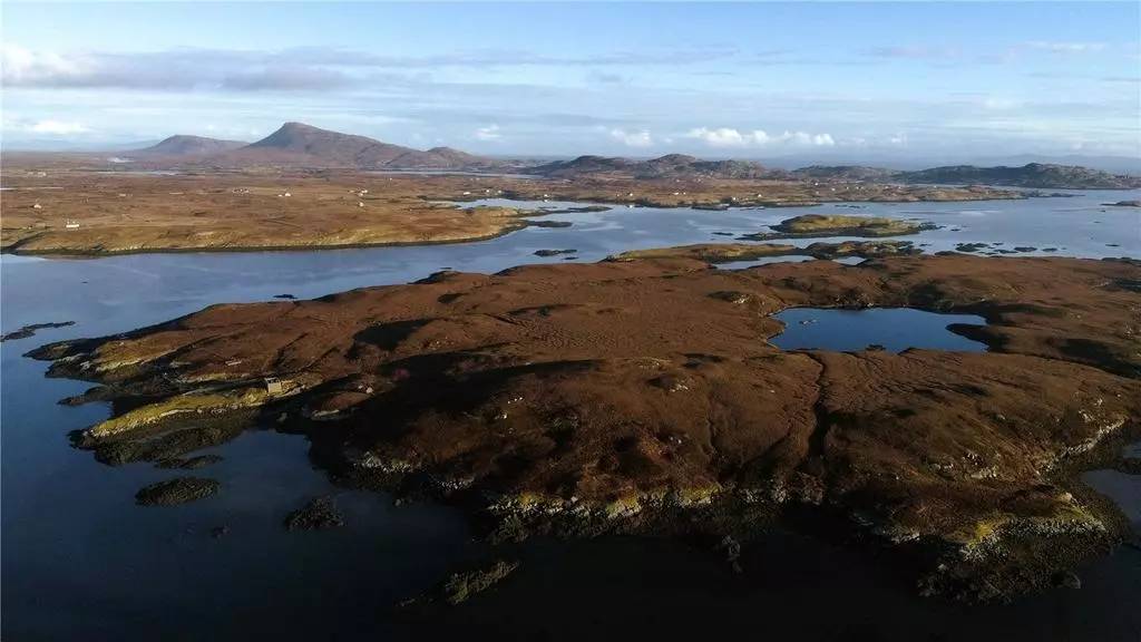
Rarely available owner-occupied croftland made up of small islands on the beautiful East coast of the Island of Benbecula extending to 119.02ha (294.10 acres). Potential to decroft an area for a croft house (subject to necessary consents)
Croft 2 Nunton Hill is located on the northeast of the Isle of Benbecula in the Western Isles. It is approximately 5 miles east of Benbecula airport. The croft has no residential property, though there are three ruined/unfinished houses. These include an archaeological site of an ancient ruin which is in the style of a Viking longhouse although it has never been established if it dates as far back as Viking occupation, the remains of a sheiling dating to the 18th century and the remains of a family residence used between 1930 and 1952.
There was also a one and a half storey house under construction up until 1952, but not completed as the island has been uninhabited since that date.
The croft is registered as an owner-occupied croft. The land is made up of various small islands and small lochs.
The total area of 2 Nunton Hill is approximately 119.02 hectares (294.10 acres). The Croft
is owner-occupier. The register number is I5422 and the croft file number is 9832.
The land is registered for IACS payments and eligible for the Basic Payment Scheme. The main location code is 465/0070. The land is classed as Severely Disadvantaged and is in payment region 3. The entirety of the croft is recorded as an area naturally kept. All the land is grade 6.3 on the Macauley National Scale of Land Capability for Agriculture which can be defined as:
6.3 ‘land is capable of only rough grazing due to intractable physical limitations; the semi-natural
vegetation provides grazing of low value’
As there is not a croft house on the croft, it may be possible to de-croft a house site subject to Crofting Commission approval and apply for Planning Permission for a dwelling house (subject to necessary consents).
Benbecula sits between North and South Uist and has white shell-sand beaches to the west and heather uplands to the east. The machair that runs alongside the sand dunes provide a marvellous habitat for the rare Corncrake. Golden Eagles, Red Grouse and Red Deer can be seen on the mountain slopes to the east.
Lochmaddy is the main settlement of North Uist, served by ferry to Uist on the Isle of Skye.
Benbecula can be reached by ferry from Uig on Skye to Lochmaddy or by the smaller ferry which weaves its way through the small islets of the Sound of Harris between Leverburgh on Harris to Berneray, connected by (non-tidal all-weather) causeways to Benbecula and also by Air from Inverness and Glasgow.
Balivanich is convenient for all local amenities including supermarkets, shops, garage, post office, primary school, and restaurant. The secondary school is approximately ten minutes’ drive from the property.
There is no electricity to the croft or any fixed water supply although there is a large fresh water loch on the island.
As the croft does not have any electricity supply, a renewable project such as a hydro scheme, wind or solar installation would need to be considered for any potential house that could be built.
From Lochmaddy take the A867 to Clachan. Turn left and follow the A865 until you reach a turn to Balivanich. The croft is formally accessed via boat to its own jetty located to the northwest. It is understood that there are no vehicular rights to access the land across the neighbouring land. It can be accessed via foot from a track which runs from Market Stance, crossing common grazing and a neighbouring property before arriving at the southern end of the croft. The section which crosses common grazing is easily accessible by 4x4.
Property information from this agent
About this agent
Situated in the Capital of the Highlands, the Inverness office team provide a broad range of land agency services ranging from traditional estate
management to utilities & pipelines, in addition to rural consultancy, estate agency and valuations. Bell Ingram Design also provide Building Surveying and
Architectural services from the Inverness office.
management to utilities & pipelines, in addition to rural consultancy, estate agency and valuations. Bell Ingram Design also provide Building Surveying and
Architectural services from the Inverness office.