
No longer on the market
This property is no longer on the market


Land
Land
115.00 acre(s)

Key information
Features and description
- Predominantly grade 5.1 land classified by the James Hutton Institute
- Currently down to cereal crops
- Small woodland shelter belt
- Located in an accessible location close to Lochgelly
- 114.96 acres (46.52 ha) in all
SITUATION
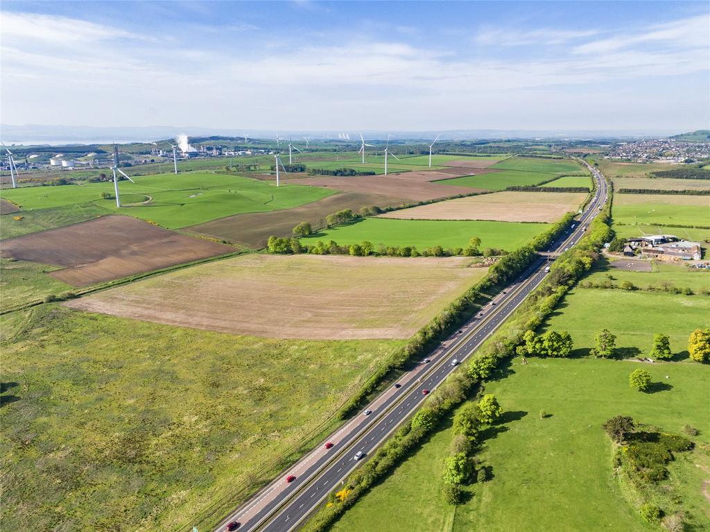
The Land At Loch Farm is located in the county of Fife and lies about 2 miles south of the town of Lochgelly. It enjoys an accessible position about a 20 minute drive from Dunfermline and a 5 minute drive to the A92 dual carriageway. The town of Lochgelly lies about 2 miles to the north and provides a shop, medical practice, church, primary and secondary schooling, as well as a variety of restaurants cafes and pubs. Dunfermline some 9 miles to the west provides a wide range of facilities including individual retailers, supermarkets, banks, hospital and rapid access to Edinburgh and Perth via the main M90 motorway.
Scotland’s Capital city, Edinburgh, is about an hour’s drive to the south providing extensive city amenities and services including two universities, national retailers, theatres and a variety of restaurants and bars. In additional there is an international airport providing services both within the UK and Europe.
Fife is renowned for its fertile land, capable of producing high yields of an extensive range of crops and the area is well suited to both arable cropping and livestock. There are a wide variety of agricultural contractors, merchants and suppliers, and successful local machinery ring which can provide additional farming resources as required as well as regular livestock sales are held at UA Stirling Agricultural Centre which is 36.5 miles to the west.
DESCRIPTION
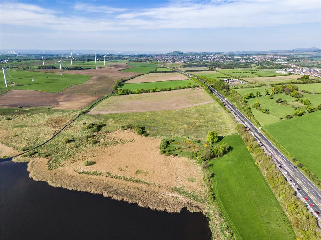
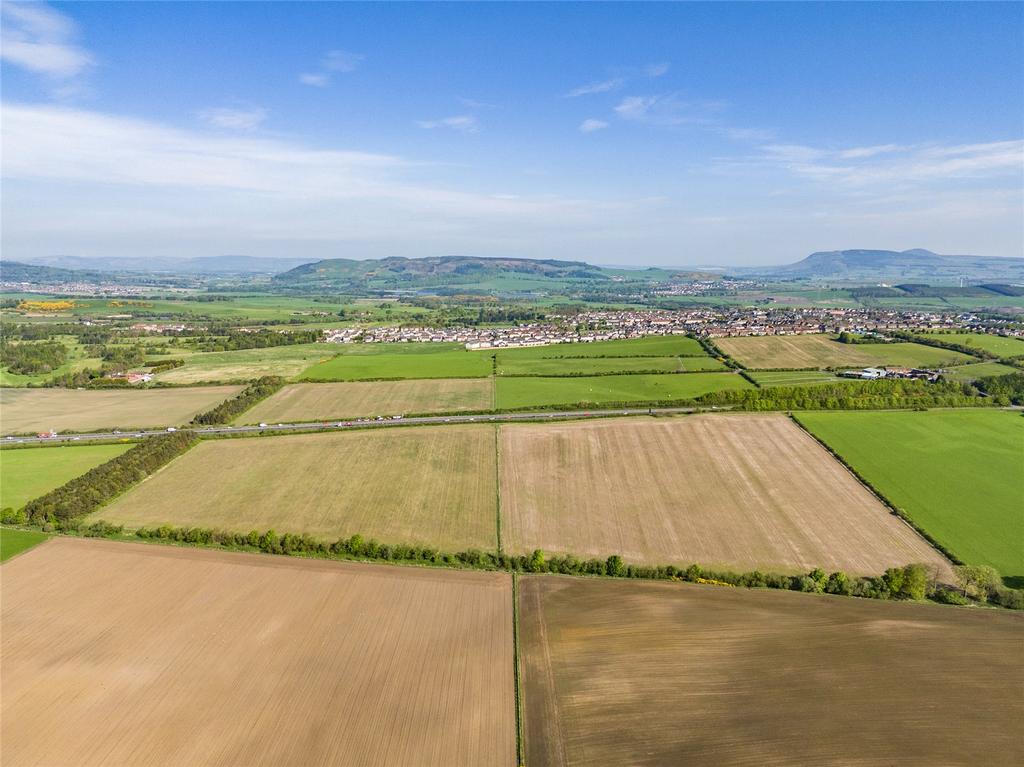
The Land At Loch Farm is a ring fenced unit of arable land lying to the south of the A92 dual carriageway and extends to approximately 114.96 acres (46.52 hectares). The Land at Loch Farm is accessed via a shared access track from the minor public road and over a flyover over the A92 onto its own farm track which runs around the northern edge of the land giving excellent access to the fields. The land is in good heart, well drained, predominately south facing and is classified as Grade 5.1 with some areas of Grade 3.2 and Grade 5.3 by the James Hutton Institute. The land is gently sloping towards the Lochgelly Burn in the south, sitting between 134 and 108 metres above sea level. The fields are of good practical size and are predominantly enclosed by fencing and mature hedging. There is also a strip of woodland to the west extending to approximately 1.49 acres (0.6 hectares).
The ground was at one time used for open cast coal mining and was re-instated in the 1980s to create productive arable ground. The land is currently down to cereal crops and has been producing good quality cereal crops on a rotational basis, with typical barley yield of approximately 2.5 tonne per acre.
There is a Scottish Gas Pipeline which runs under Field 24 as well as the A92, however the field is still safe for agricultural machinery.
The Land At Loch Farm is located in the county of Fife and lies about 2 miles south of the town of Lochgelly. It enjoys an accessible position about a 20 minute drive from Dunfermline and a 5 minute drive to the A92 dual carriageway. The town of Lochgelly lies about 2 miles to the north and provides a shop, medical practice, church, primary and secondary schooling, as well as a variety of restaurants cafes and pubs. Dunfermline some 9 miles to the west provides a wide range of facilities including individual retailers, supermarkets, banks, hospital and rapid access to Edinburgh and Perth via the main M90 motorway.
Scotland’s Capital city, Edinburgh, is about an hour’s drive to the south providing extensive city amenities and services including two universities, national retailers, theatres and a variety of restaurants and bars. In additional there is an international airport providing services both within the UK and Europe.
Fife is renowned for its fertile land, capable of producing high yields of an extensive range of crops and the area is well suited to both arable cropping and livestock. There are a wide variety of agricultural contractors, merchants and suppliers, and successful local machinery ring which can provide additional farming resources as required as well as regular livestock sales are held at UA Stirling Agricultural Centre which is 36.5 miles to the west.
DESCRIPTION
The Land At Loch Farm is a ring fenced unit of arable land lying to the south of the A92 dual carriageway and extends to approximately 114.96 acres (46.52 hectares). The Land at Loch Farm is accessed via a shared access track from the minor public road and over a flyover over the A92 onto its own farm track which runs around the northern edge of the land giving excellent access to the fields. The land is in good heart, well drained, predominately south facing and is classified as Grade 5.1 with some areas of Grade 3.2 and Grade 5.3 by the James Hutton Institute. The land is gently sloping towards the Lochgelly Burn in the south, sitting between 134 and 108 metres above sea level. The fields are of good practical size and are predominantly enclosed by fencing and mature hedging. There is also a strip of woodland to the west extending to approximately 1.49 acres (0.6 hectares).
The ground was at one time used for open cast coal mining and was re-instated in the 1980s to create productive arable ground. The land is currently down to cereal crops and has been producing good quality cereal crops on a rotational basis, with typical barley yield of approximately 2.5 tonne per acre.
There is a Scottish Gas Pipeline which runs under Field 24 as well as the A92, however the field is still safe for agricultural machinery.
Property information from this agent
About this agent
Galbraith is a leading independent property consultancy specialising in Estate Agency Sales and Lettings, Farm, Estate and Country House sales and acquisitions. With offices across Scotland and Northern England including Aberdeen, Ayr, Blagdon, Castle Douglas, Cupar, Edinburgh, Hexham, Inverness, Kelso, Morpeth, Penrith, Perth and Stirling. We provide local knowledge, national expertise and international reach. To find out more about Galbraith visit our website or follow us on Facebook, Twitter, Instagram, TikTok and Linkedin.