


Guide price
£300,000Land for sale
Park Road, Hook Norton
Land
Key information
Tenure: Freehold
Council tax: Ask agent
Features and description
- Tenure: Freehold
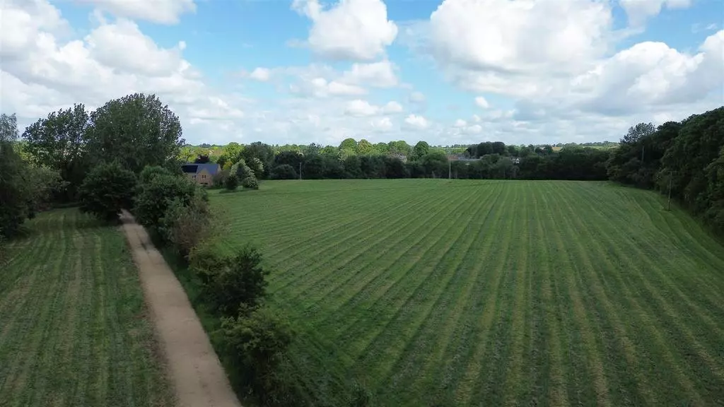
This is a level parcel of farmland on the fringe of Hook Norton Village, totaling some 12.5 acres.
Location - Hook Norton is a popular, well-served vibrant Oxfordshire village situated just outside the Cotswolds Area of Outstanding National Beauty. Hook Norton is close to centres such as Banbury (9 miles with M40 link), Charlbury (12 miles), both with main trainline stations to London, Chipping Norton (5.5 Miles), Stratford-upon-Avon (22 miles) and Oxford (25 miles). There is also a local bus service. The village itself has a wonderful community with a village shop, Post Office, Doctors and Dental Surgeries, Library, Public Houses, Brewery, well-regarded Primary School and secondary education is available at Chipping Norton.
Description - The land is situated on the eastern fringe of Hook Norton Village. The Park is a total of 12.5 acres, primarily comprised of grade 3 arable farmland but also includes approximately 2 acres of mixed amenity woodland. The areas of woodland are situated on the northern and southern extremities of the land. Within the woodland to the north of the property the benefits from single bank ownership of a small tributary to the River Swere.
The land is classified as good to moderate arable farmland, it is however currently in a well maintained long term grass ley for the production of Hay.
Woodland And Trees - The Park benefits from approximately 2 acres of amenity woodland, one large parcel of c.1.75 acres on the north edge of the land and a smaller parcel of c.0.25 acres on the southern edge. The woodland is a mix of native broadleaf trees including oak and ash. Our investigations do not reveal that this land is within any Woodland Management or Environmental grant schemes.
There are also some amenity in field trees and trees running along the access track.
Access - The land benefits from a right of access over the access track shown dissecting the two field parcels. However, the neighbouring landowner to the east of The Park retains ownership and right of access over this track.
Designations - The land is within a Nitrate Vulnerable Zone. Whilst this is an old railway line our investigations do not reveal the property as having any historic designations imposed upon it. The land sits within a Conservation Area designated for planning controls by the Cherwell District Council,. We have also been advised that there is a tree preservation order in place. The land is not within the Cotswolds Areas of Outstanding National Beauty.
Sporting Rights - We believe that the sporting rights are included in the sale.
Rights Of Way - The land is subject to statutory designated footpaths and Bridleways crossing the land. The access track is a known bridle way and the there are footpaths crossing the northern parcel of farmland.
Wayleaves And Easements - The land is sold with the benefit of all rights of way (whether public or private), light, support, drainage, water supplies and other rights and obligations, easements, quasi-easements and restrictive covenants and all wayleaves for poles, stays, cables, drains and water, gas and other pipes, whether referred to in these particulars or otherwise and subject to all outgoings or charges connected whether mentioned or not.
Tenure & Possession - Freehold. Vacant possession will be given upon completion.
Services - To our knowledge the land does not currently have any services, but due to the proximity to the village we believe these could be obtained.
Directions - The land is accessed off Park Road or Park Hill road, south east region of Hook Norton. The access track is situated at What 3 Words: ///dives.darkens.prominent
Method Of Sale - This parcel is offered for sale by Private Treaty.
Local Authority - Cherwell District Council
Bodicote House
Bodicote
Banbury
Oxfordshire
OX15 4AA
Telephone:[use Contact Agent Button]
Viewings - May ONLY be undertaken during daylight hours in possession of a copy of these particulars and STRICTLY by prior appointment with Tayler & Fletcher
Health And Safety - For your own safety please do take extra care when accessing the site, we cannot sure that there are some hazards obscured in the undergrowth. We do not take any responsibility for unattended inspections.
Property information from this agent
About this agent
Independent Cotswolds Estate Agent and Chartered Surveyors with Residential, Commercial, Agricultural and Fine Art departments providing sales, lettings, professional and valuation advice