Offers in region of
£135,000Land for sale
Land to the South of Lower Frankton, Oswestry
Land
Key information
Tenure: Freehold
Council tax: Ask agent
Features and description
- Tenure: Freehold
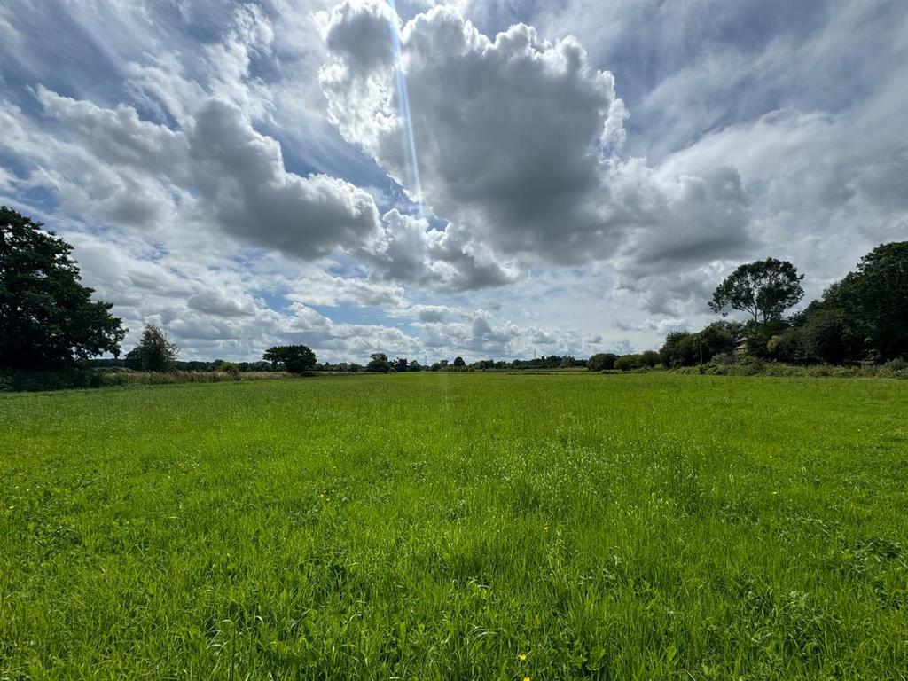
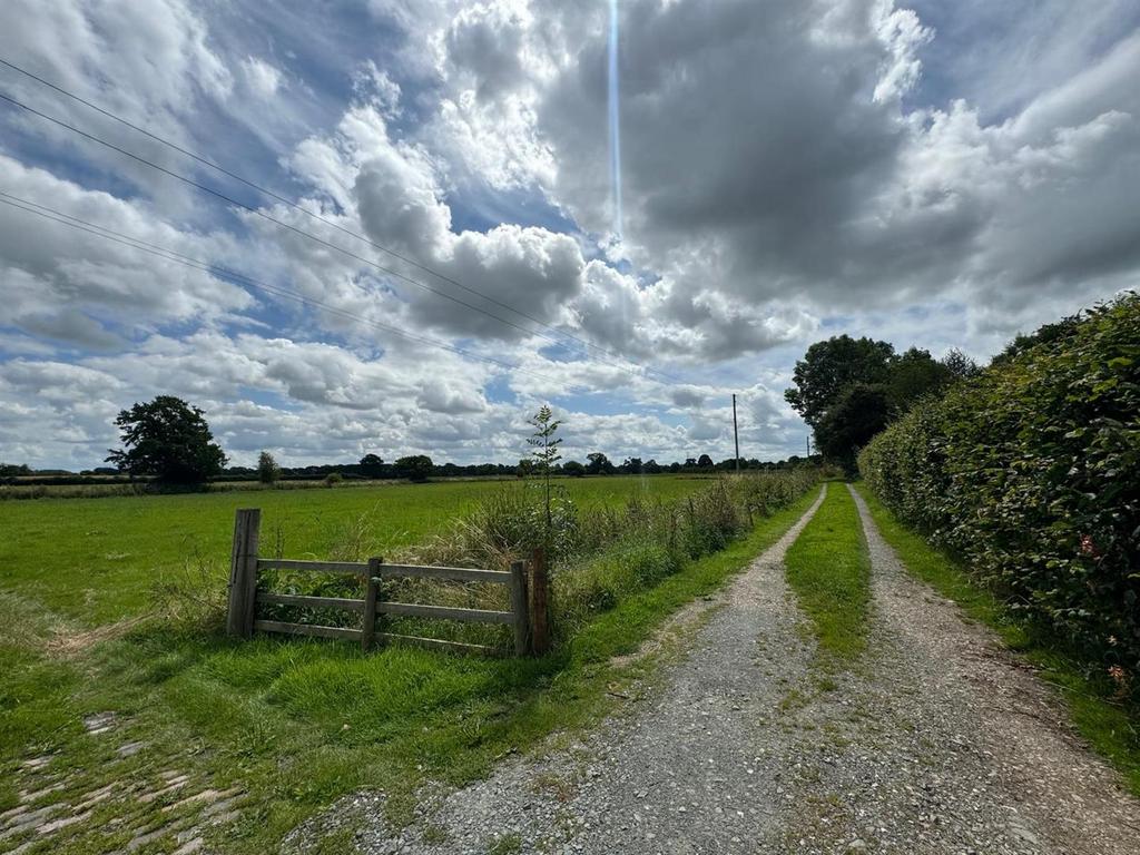
The land south of Lower Frankton encompasses 13.795 acres (5.583 ha) of grassland. We are pleased to present this highly versatile farmland to the market. Currently, the land is under a grass ley, adjacent to the Montgomery Canal. Additionally, it is suitable for various uses such as amenity land and emerging environmental schemes. The land is well-defined with established boundaries and can be accessed via the entrance at the northwest. There is also a right of way along the track adjacent to the west boundary, which includes two additional access gates.
The Land is available in its entirety, presenting a unique opportunity for prospective buyers to acquire a substantial and flexible piece of land. Whether your interest lies in traditional farming, innovative environmental projects, or creating recreational spaces, this land offers the potential to fulfil a wide range of aspirations.
Description - The land south of Lower Frankton encompasses 13.795 acres (5.583 ha) of grassland. We are pleased to present this highly versatile farmland to the market. Currently, the land is under a grass ley, adjacent to the Montgomery Canal. Additionally, it is suitable for various uses such as amenity land and emerging environmental schemes. The land is well-defined with established boundaries and can be accessed via the entrance at the northwest. There is also a right of way along the track adjacent to the west boundary, which includes two additional access gates.
The Land is available in its entirety, presenting a unique opportunity for prospective buyers to acquire a substantial and flexible piece of land. Whether your interest lies in traditional farming, innovative environmental projects, or creating recreational spaces, this land offers the potential to fulfil a wide range of aspirations.
Overview - The land is currently leyed to a grass ley used for grazing animals and silage production. The land is of flat terrain. To the west and south of the land runs the Montgomery Canal. Main access is gained into the land at the northwest corner through a single track and gateway, along with 2 other entrances which are accessed down a separately owned track.
Boundaries - Any purchaser shall be deemed to have full knowledge of all boundaries and neither the Vendor nor the Vendors Agents are responsible for defining the boundaries or ownership thereof.
Mineral Rights - Included within the sale.
Sporting Rights - Included within the sale.
Public Rights Of Way - There is no public rights of way on the land.
Location - The land is situated to the southwest of Ellesmere, 7 miles from Oswestry and 15.5 miles from Whitchurch. All distances are approximate.
Wayleaves, Rights And Easements - The land is sold subject to all existing wayleaves and purchasers must satisfy themselves as to the routes thereof. The land is sold subject to and with the benefit of all rights including private and public rights of way, sewage, water, gas and electricity supply, light, support and any other easements.
Tenure And Posession - Freehold. Vacant possession will be given on completion subject to contract.
Viewing - Viewing must be undertaken on foot in daylight hours prior to arrangements with Roger Parry and Partners. A set of particulars must be carried at all times when conducting the viewing. Please be aware of potential hazards on the land when viewing.
Local Authority - Shropshire County Council, Shirehall, Shrewsbury, SY2 6ND
Method Of Sale - Land to the South of Lower Frankton is offered for sale by Private Treaty. Prospective purchasers should register their interest with selling agents to who offers should be submitted.
Offers - Offers are invited in the region of £135,000.
What Three Words - marzipan.pipe.grins
The Land is available in its entirety, presenting a unique opportunity for prospective buyers to acquire a substantial and flexible piece of land. Whether your interest lies in traditional farming, innovative environmental projects, or creating recreational spaces, this land offers the potential to fulfil a wide range of aspirations.
Description - The land south of Lower Frankton encompasses 13.795 acres (5.583 ha) of grassland. We are pleased to present this highly versatile farmland to the market. Currently, the land is under a grass ley, adjacent to the Montgomery Canal. Additionally, it is suitable for various uses such as amenity land and emerging environmental schemes. The land is well-defined with established boundaries and can be accessed via the entrance at the northwest. There is also a right of way along the track adjacent to the west boundary, which includes two additional access gates.
The Land is available in its entirety, presenting a unique opportunity for prospective buyers to acquire a substantial and flexible piece of land. Whether your interest lies in traditional farming, innovative environmental projects, or creating recreational spaces, this land offers the potential to fulfil a wide range of aspirations.
Overview - The land is currently leyed to a grass ley used for grazing animals and silage production. The land is of flat terrain. To the west and south of the land runs the Montgomery Canal. Main access is gained into the land at the northwest corner through a single track and gateway, along with 2 other entrances which are accessed down a separately owned track.
Boundaries - Any purchaser shall be deemed to have full knowledge of all boundaries and neither the Vendor nor the Vendors Agents are responsible for defining the boundaries or ownership thereof.
Mineral Rights - Included within the sale.
Sporting Rights - Included within the sale.
Public Rights Of Way - There is no public rights of way on the land.
Location - The land is situated to the southwest of Ellesmere, 7 miles from Oswestry and 15.5 miles from Whitchurch. All distances are approximate.
Wayleaves, Rights And Easements - The land is sold subject to all existing wayleaves and purchasers must satisfy themselves as to the routes thereof. The land is sold subject to and with the benefit of all rights including private and public rights of way, sewage, water, gas and electricity supply, light, support and any other easements.
Tenure And Posession - Freehold. Vacant possession will be given on completion subject to contract.
Viewing - Viewing must be undertaken on foot in daylight hours prior to arrangements with Roger Parry and Partners. A set of particulars must be carried at all times when conducting the viewing. Please be aware of potential hazards on the land when viewing.
Local Authority - Shropshire County Council, Shirehall, Shrewsbury, SY2 6ND
Method Of Sale - Land to the South of Lower Frankton is offered for sale by Private Treaty. Prospective purchasers should register their interest with selling agents to who offers should be submitted.
Offers - Offers are invited in the region of £135,000.
What Three Words - marzipan.pipe.grins
Property information from this agent
About this agent

Roger Parry & Partners - Oswestry
The Estates Office, 20 Salop Road
Oswestry, Shrewsbury
SY11 2NU
01691 721940As estate agents and chartered surveyors our specialism is property. We have a strong presence in the residential, agricultural and commercial sectors. We have a highly successful planning and development team offering a complete service backed by wide experience. Established in 1981, the residential team have over 200 years of collective experience, providing a wealth of knowledge relating to the area, local amenities and facilities, along with details on any potential developments. We pride ourselves in being a team who are passionate about what we do, we are always willing to go that extra mile and provide first class service. If you are considering selling your home, at Roger Parry and Partners we believe your home is your most valuable asset and choosing an Estate Agent to sell your home is a very important decision which cannot be taken lightly. Please contact us today to discuss the range of services we can offer.


