

Woodland for sale
Key information
Property description & features
DESCRIPTION
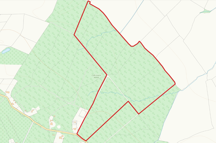
The Land at Collinpark Wood extends to a total of 57.72 acres (23.36 Ha) of mixed broadleaf woodland and forms part of the larger Collinpark Wood Site of Special Scientific Interest (SSSI). The woodland is gently sloping and benefits from an access track from leading from the highway.
The woodland was designated a SSSI in 1966 as a nationally important woodland site selected as an outstanding example of damp Calcifuge Lime woodlands in western Britian.
Collinpark Wood is mapped on the Priority Habitat Inventory (England) as Deciduous Woodland and is classified as Ancient Semi-Natural Woodland.
SITUATION
Collinpark Wood is located approximately 10 miles to the northeast of the city of Gloucester and 0.4 miles to the northwest of the village of Upleadon in the county of Gloucestershire.
METHOD OF SALE
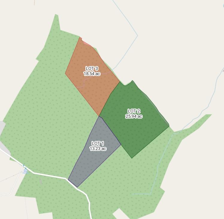
The property is offered for sale by Private Treaty. Available as a whole or in 3 lots. The vendor reserves the right to set a date for Best and Final offers.
LOT 1- Guide Price- £105,000
• 13.23 acres (5.35 hectares)
LOT 2- Guide Price- £190,000
• 25.94 acres (10.50 hectares)
LOT 3- Guide Price- £145,000
• 18.54 acres (7.50 hectares)
SERVICES
There are no mains services connected to the property. Interested parties are encouraged to make their own enquiries.
ENVIRONMENTAL SCHEMES
The land is not included in any environmental schemes.
ACCESS
The land is accessed via a set of double gates off Eden’s Hill. There is a forestry ride running into the wood. If the property is sold in multiple lots a right of access will be granted over lots 1 and 2, along the forestry track to lots 2 & 3. A map of the forestry rides is available from the selling agents.
RIGHTS OF WAY, WAYLEAVES AND EASEMENTS
The property is sold subject to and with the benefit of rights, including rights of way, whether public or private, light, support, drainage, water and electricity and other rights and obligations, easements, quasi easements and restrictive covenants and all existing and proposed way leaves or masts, pylons, stays, cables, drains and water, gas or other pipes, whether referred to in the general remarks and stipulations or particulars of sale or not and to the provision of any planning scheme of County or Local Authority.
BOUNDARIES & AREAS
The purchaser shall be deemed to have full knowledge of the boundaries and neither the Vendors nor the Agents will be responsible for defining the boundaries or ownership thereof.
TENURE AND POSSESSION
The property is offered Freehold with Vacant Possession.
LOCAL PLANNING AUTHORITY
Forest of Dean District Council Tel.[use Contact Agent Button]
VIEWINGS
The property may be viewed during daylight hours with a set of sales particulars after first registering your interest with Carver Knowles. Please note that neither the vendor nor Carver Knowles can take responsibility for any loss or injury caused whilst carrying out a site visit.
ANTI MONEY LAUNDERING REGULATIONS
Interested parties will be required to provide photographic ID and proof of address for Anti Money Laundering checks prior to instructing solicitors. Proof of funds will also be required.
DIRECTIONS
From the town of Newent – Take the B4215 south towards Gloucester. After approximately 0.5 miles turn left onto Hook’s Lane. After approximately 1.3 miles, turn left onto Gloucester Road. Continue for 0.5 miles and at the T-junction continue straight ahead onto Eden’s Hill. Continue ahead for a futher 0.5 miles and the access to Collinpark Wood can be seen on the right marked with an Agent’s For Sale board.
(Postcode for Sat Nav GL18 1EE)
What3Words: dogs.juggled.hunter
Property information from this agent
Places of interest
See more properties like this:
*DISCLAIMER
Property reference Collins. The information displayed about this property comprises a property advertisement. OnTheMarket.com makes no warranty as to the accuracy or completeness of the advertisement or any linked or associated information, and OnTheMarket.com has no control over the content provided by the agent or developer. This property advertisement does not constitute property particulars. The information is provided and maintained by Carver Knowles - Worcester.
OnTheMarket may have applied supplementary data to this property listing, including:
Broadband availability and predicted speed: obtained from Ofcom on September 22, 2023
Broadband speed is measured in megabits per second, with the number returned showing how fast the connection is. Each reading is based on the highest predicted speed of any major broadband network for services that deliver the download speeds. The following are the different readings that we may display:
Basic: Up to 30 Mbit/s
Super-fast: Between 30 Mbit/s and 300 Mbit/s
Ultra-fast: Over 300 Mbit/s
The data is updated three times a year. The checker results are predictions and should not be regarded as guaranteed. For more information, see: https://checker.ofcom.org.uk/en-gb/about-checker#Answer_0_2
Mobile phone signal availability and predicted strength
Mobile signal predictions are provided by the four UK mobile network operators: EE, O2, Three and Vodafone. Predictions can vary significantly from the coverage you may actually experience as a result of local factors (especially terrain). Ofcom has tested the actual coverage provided in various locations around the UK to help ensure that these predictions are reasonable. The values shown against a property can be broken down as follows:
Clear: No bars, no signal predicted
Red: One bar, reliable signal unlikely
Amber: Two bars, may experience problems with connectivity
Green: Three bars, likely to have good coverage and receive a data rate to support basic web services
Enhanced: Full bars, likely to have good coverage indoors and to receive an enhanced data rate to support multimedia services
Energy Performance data and Internal floor area
Any supplementary data should not be relied upon as forming part of any property particulars and OnTheMarket cannot be held responsible for any incorrectness in this data. See here for more information.
