


Popular
Total views: 500+
Offers over
£6,750,000Land for sale
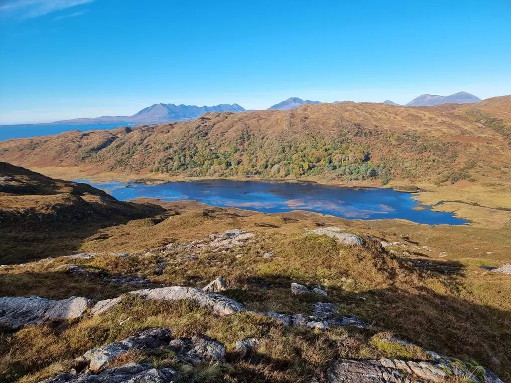
Sleat Peninsula, Isle Of Skye
Featured
Study
Land
19,208.00 acre(s)
Key information
Features and description
FEATURES
Extensive areas of open moorland with pockets of remnant native woodland varying between sea level and 292 metres (973 feet) in altitude.
Over 20 miles (32 km) of rocky coastline wrapping around the southern tip of Skye at Point of Sleat featuring a number of bays, inlets, coves and beaches.
About 1,055 acres (427 ha) of established and enclosed mixed species native woodland.
About 660 acres (267 ha) of enclosed forestry/woodland compartments planted in 2014 with grant support from the Scotland Rural Development Programme (SRDP).
The entirety of the Loch a’ Ghlinne and Allt Ghlinne river system which, together with the native woodlands throughout Gleann Meadhonach form an important ecosystem and a truly spectacular landscape lying right at the heart of the estate.
Over 17,000 acres (6,880 ha) of peat-based soils of variable depth with a feasibility study identifying a 1,400-acre (566 ha) area with restoration and carbon accreditation potential under The Peatland Code subject to grant funding application.
Extensive potential for further native woodland enhancement and creation with associated
carbon accreditation opportunities under the Woodland Carbon Code.
Potential for future wind development with an Exclusivity Agreement signed in favour of a Wind Developer.
A rich variety of terrestrial and marine flora and fauna including several rare and endangered species.
An environmental landscape recognised for its importance through four different Sites of Special Scientific Interest (SSSI), one Marine Protection Area (MPA) and one Special Area of Conservation (SAC).
A range of redundant 19th Century estate buildings together with other sites offering residential development and/or eco-tourism potential, subject to planning.
Traditional sportings including red deer stalking and rough shooting for mixed game including woodcock, snipe and wild duck together with sea trout and brown trout fishing.
Mixed land tenure including crofting and common grazings; a Limited Duration Agricultural Tenancy; Annual Grazing Agreements and land/woodland with vacant possession.
About 19,208 acres (7,773 ha) in total.
CURRENT OWNERSHIP HISTORY AND BACKGROUND TO SALE
South Sleat Estate represents the majority of the land ownership of the Clan Donald Lands Trust (CDLT). The estate once formed part of the
traditional lands of Clan Donald, indisputably the most renowned of all the Highland clans of Scotland. In 1971 these lands came up for sale
following the death of Alexander Godfrey Macdonald, 7th Lord Macdonald and High Chief of Clan Donald. A charitable trust, the CDLT, was founded by Clan Donald members local and worldwide in order to buy out part of the old
Macdonald Estate to preserve and promote the history, heritage and culture of Clan Donald.
The Clan Donald has exercised a powerful influence on Highland history. For almost 400 years the Clan ruled the western seaboards of
Scotland, controlling an empire big and powerful enough to challenge the Scottish kings.
Translated literally as ‘children of Donald’ it was named after Donald, grandson of the 12th century Gaelic hero Somerled. Donald gave his descendants and followers the name of Macdonald or the son of Donald. The Clan’s leaders were Lords of the Isles, ruling over a sea kingdom of
the western islands and west coast of Scotland, virtually independent of royal control. Their home and the centre of the Lordship was at Loch Finlaggan, on the Isle of Islay, often referred to as the Cradle of Clan Donald.
They remained Lords of the Isles until the forfeiture of the Lordship in 1493, when the Scottish king took the title away. However, the influence of Clan Donald survived.
Clan Donald is the oldest and largest of the Highland clans with many other clans owing their existence to the ancient Clan Donald Lordship of the Isles. More than 40 tartans are associated with the name, and the histories of the various clan
branches are intricately connected. The seven main branches – Antrim, Ardnamurchan, Clanranald, Glencoe, Glengarry, Keppoch and
Sleat – once held extensive estates from Ulster to Skye.
Clan Donald itself encompasses over 400 surnames in addition to the commonly known Macdonald, McDonald and MacDonell. These are listed on the High Council of Clan Donald website, which is an excellent resource.
Gradually, these lands were sold or confiscated. In 1971, the last remaining lands to be held by one
of the Clan chiefs came up for sale. These were the lands in Skye of which the subjects now for sale are the heart. Just under half of the lands
were purchased by the CDLT with the remaining majority being purchased by prominent Scottish businessman, the late Sir Iain Noble. Clan Donald
is still the largest clan in Scotland and the descendants of thousands of Macdonalds who emigrated also make it the largest in the world.
CDLT is a Scottish Registered Charity, Number SC007862, which is dedicated to promoting and preserving the history and heritage of Clan Donald,
the Lordship of the Isles, and the unique culture of the western seaboard of Scotland and the Hebrides.
The focal point of the estate and the activities of CDLT is at Armadale Castle, Gardens and Museum on the east coast of the peninsula just north of the
settlements of Armadale and Ardvasar.
In recognition of a desire to ensure the long-term financial stability of the charity as a custodian of the history and heritage of Clan Donald and local culture, the CDLT Trustees have taken the decision to offer the estate for sale as a whole.
It is the Trustees’ intention that the proceeds of sale will enable the charity to complete its restructure as a grant-giving body, enabling
investment in heritage and culture long into the future.
DESCRIPTION OF SALE SUBJECTS
The subjects of sale represent an extensive upland estate occupying a picturesque and richly varied
landscape of which the majority is bound by a coastline extending to just over 20 miles in total.
The estate has been managed by the current owners as an upland estate with varying land uses including traditional field sports; low intensity
livestock-based agriculture; forestry and woodland establishment/management; tourism and
landscape enhancement.
Whilst this matrix of land use and enjoyment can continue under new ownership in future, the owners acknowledge that the motivations for land ownership and use in Scotland have evolved in recent years in accordance with a wider imperative to tackle the global climate emergency with
opportunities for enhancement and restoration of natural landscapes and their component biological
species – particularly at landscape scale – offering powerful attractions to purchasers of various types.
In common with most parts of the northern and western Highlands of Scotland, crofting communities are a feature of both the cultural heritage and 21st Century population of the Sleat peninsula and they have various rights enshrined within Scottish legislation.
With several crofting townships occupying parts of the north-western and eastern coasts of the peninsula, substantial parts of the estate are
subject to both individual croft tenancies and common grazings rights necessitating a collaborative approach to current and future
management.
On account of its scale and composition, together with its mix of stakeholders and future opportunities, South Sleat Estate offers exceptional potential for purchasers to embrace land
management and nature restoration which provides extensive local, national and international
community benefit and can create a legacy of which the future owner, the community of Sleat, the Isle of Skye and the wider Scottish public can be truly proud.
EXISTING COMPOSITION/LAND USE
The existing composition and land use of the estate is summarised within the brochure (page 10).
FARMING
With land varying in elevation from close to sea level to 292 metres (660 feet) and with the vast majority comprising open hill land classified as grade 6 according to Scotland’s Soils online mapping data (‘land capable of use as rough grazings with a high proportion of palatable plants’), agricultural activity on South Sleat Estate – and the rest of Skye – is by means of low intensity grazing of sheep and cattle with the aim of producing lambs/calves for sale to be fattened ahead of slaughter on better land elsewhere.
Within South Sleat Estate, this type of farming is undertaken by a combination of crofters and
common graziers, together with one farm tenant and five annual graziers.
Situated on the eastern side of the estate and occupying the land lying either side of the Ostaig to Achnacloich minor public road is Armadale Home Farm – an area extending to around 2,400 acres of mostly open hill and rough grazing but also including some better quality fields of in-bye on the lower lying areas close to the coast.
Having been farmed on an in-hand basis by CDLT for many years, the economics of upland farming were such that the Trustees took the decision to grant a tenancy over this land and, on that basis, it is currently let under a Modern Limited Duration
Tenancy (MLDT) at an annual rent of £7,500. The lease was granted in November 2019 for a 15-year term until November 2032.
The tenant owns the registered Entitlements to the Basic Payment Scheme and his current system of farming is based on a flock of c.700 Scottish Blackface ewes and a small herd of around 26 suckler beef cows.
With no residential property included in the lease, the fixed equipment comprises a single general purpose shed with associated cattle handling facilities and sheep fank situated beside the
minor public road.
Within the let subjects – with an attractive southerly aspect lying about 50 metres from the public road – is a stone and tile-roofed bothy
which has potential for residential development subject to both resumption from the tenancy and
planning consent.
In addition to the subjects of the MLDT, there are two areas of open hill land/rough grazing which are leased annually to two separate graziers. Lying on either side of Gleann Meadhonach, at the heart of the estate, and extending to about 3,850 acres in total. The rent payable under these agreements in 2025 is £2,500. In addition, there are three
further smaller areas of hill ground leased annually for grazing at a combined rent of £1,300 in 2025.
Each agreement is renewable annually with no obligation for a purchaser to renew any of these
agreements beyond their current termination date.
WOODLAND AND FORESTRY
The woodland and forestry element of the estate comprises a combination of native (mainly broadleaved) woodland some of which is enclosed
to exclude deer and livestock and other parts of which are within the open hill ground, and young mainly coniferous plantations which were
established with grant support within the last 15 years.
The enclosed native woodland lies within Gleann Meadhonach being Gaelic for ‘Middle Glen’. The larger area extends to about 796 acres (322 ha) and occupies the north side of the glen together with part of the plateau above it.
This woodland is of national importance and is dominated by sessile oak and downy birch with a
variety of other species including ash, rowan and hazel. The Woodland Inventory suggests that there has been a continuity of woodland cover on the site for at least 230 years and that the woodland is likely to contain modified remnants of
Scotland’s original forest cover. The canopy is largely complete on the slopes to the north of the loch and includes stands of mature beech and Scots pine.
At the head of the glen and lying on either side of the access track is the smaller enclosure extending
to about 259 acres (93 ha). First enclosed in the 1990s to encourage natural regeneration of the remnant woodland, this has been successfully
established as a rich woodland ecosystem of varying density with all native species including birch, ash, rowan, willow, Scots pine, alder, aspen, hazel and holly well-established and thriving.
With areas of open heath and water courses diving the thickets and stands of trees, this wood is alive
with bird, animal and insect life with summer migrant bird species such as cuckoo, reed warbler,
grasshopper warbler, stonechat and wheatear being present.
Beyond these enclosures, similarly attractive and important unenclosed woods exist in the valley of the Gillean Burn and around the settlement of Achnacloich; and also on the north-western coast of the estate around Tokavaig.
On the eastern side of the estate are five enclosures of in-hand young forestry/woodland which extend in total to about 660 acres (267 ha)
combining the established crop and designed open ground within the enclosures.
Established under two separate contracts, these plantations were funded by the Scotland Rural
Development Programme which ran between 2007 and 2013 with planting having taken place at the
end of the scheme in 2014.
The estimated species composition of the enclosures, based on a recent independent assessment, can be found at page 13 of the sales brochure.
Approaching the end of the grant scheme contract, an independent assessment of these woods by a
forest management consultant has been commissioned by the vendors and is available to review on request from the selling agents.
CARBON SEQUESTRATION
According to data published by PeatScope on-line environmental mapping tool, there are in excess of
17,000 acres (7,000 ha) of peat-based soils at South Sleat comprising:
3,857 ha of deep peat soils (>50 cm)
1,309 ha of shallow peat soils (15 – 50cm)
1,797 ha of variable depth with rock outcrops.
The peatland condition categories that have been allocated to peatland areas on the estate, according to PeatScope data, can be found at page 14 of the sales brochure.
In order to understand and explore the opportunities for peatland restoration, a feasibility report was commissioned by Peatland Action
over a c.1,500-acre (600 ha) site on the north-eastern part of the estate around Loch Mhic Charmhiceil.
The study was undertaken and a report produced in 2021 by MNV Consulting Ltd. The main findings
of the report were:
A gross area extending to approximately 568 ha could be restored.
Erosion features included:
c.14km of small haggs (<1m tall)
c.6km of medium haggs (1-2m tall)
c. 2km of gullies
c. 2km of peat cuttings and c. 65ha of bare peat area.
The estimated cost of restoration works was c. £420,000.
In addition to this, a desktop analysis has been undertaken to understand the peatland extent and condition on other parts of the estate. This has
been partially supplemented by a site visit.
From this research, it is noted that outwith the feasibility study area assessed by MNV Consulting Ltd, there are several pockets of deep and degraded peat elsewhere on the estate but these are fairly limited in extent and isolated. In some areas, it was noted that peat had become so degraded that it was unlikely to be capable or economic to restore.
The total volume of carbon that this project could sequester and therefore the estimated number
of carbon credits that may be accredited under the Peatland Code has not been formally determined
but is anticipated to be reasonably significant. Prospective purchasers are advised to seek independent advice in this regard.
RENEWABLE ENERGY
In order to enable the charity, together with the crofting and wider local community, to benefit in the event of a wind energy development on the estate being both feasible and approved by the Highland Council/Scottish Ministers, the vendors
have entered into an Exclusivity Agreement with a developer – GGE Scotland Ltd.
The area subject to this Agreement extends to approximately 10,000 acres (4,000 ha). The developer is undertaking due diligence surveys
but has not submitted a Scoping Report.
The Exclusivity Area incorporates land subject to varying tenure and therefore – in the event of a
successful planning application for development and the commissioning of a constructed wind farm – the revenue under the lease will be shared (subject to negotiation and agreement) amongst the various stakeholders in addition to the
landowner.
The Exclusivity Agreement for feasibility work comes to an end on 31 May 2025 and there is no
commitment to a wind energy development. After completion of sale, the purchaser will have the
option to explore options with the developer, including negotiating terms.
With regard to hydroelectricity generation, there are no existing installations at present nor any
recent feasibility studies. There are various watercourses throughout the estate which may offer the opportunity for hydroelectricity
generation in future, subject to appropriate due diligence and planning consent.
PLANNING AND DEVELOPMENT
While there are no existing dwellings forming part of the subjects of sale, there are several sites which offer the potential for the development
of residential, commercial or quasi-commercial facilities in future, subject to due diligence and
planning consent. These include:
Armadale Home Farm Steading
This is an extensive range of stone and slate farm buildings including a former dwelling arranged around a courtyard with a more recent general
purpose shed adjoining part of the range to the rear. In dilapidated condition and functionally obsolete, this site is located close to the eastern edge of the estate with an elevated setting with magnificent views to the North Morar and
Knoydart peninsulas.
The site is served by mains electricity and water together with private drainage and offers rich potential for development for a variety of uses
including as a future principal house serving the estate or for several residential units and/or retail/
commercial space.
Whilst the vendors have sought opinions from local builders regarding the integrity of the existing
buildings, no formal feasibility studies nor development plans have been commissioned.
Land within the Kilbeg
Village Development Plan Situated between the A851 public road and the eastern shoreline of the estate/peninsula – a short distance from the campus of Sabhal Mor Ostaig (the National Centre for the Gaelic Language and Culture forming part of the wider University of the Highlands and Islands) – is an area of land that lies within the
Kilbeg Village Development Plan.
Launched in 2014 with key funding bodies including Highlands & Islands Enterprise, The Scottish Funding Council, the European ERDF Programme, Highland Council and the Sabhal Mor Ostaig Development Trust, the Kilbeg Initiative was designed to enable the creation of the first new planned village on Skye in almost 100 years.
The early phases of this project have seen the building of new academic and research facilities serving Sabhal Mor Ostaig with future phases of the project aimed at providing a range of housing, retail and enterprise units, a small hotel and sports and recreation facilities for both the college and
wider community.
With part of the subjects of sale lying within the overall site of the Kilbeg Village Development Plan, there is a particular site with good access from
the public road and a fine outlook which lends itself to a residential and/or commercial development subject to due diligence and planning.
Sites in Gleann Meadhonach
Situated in the heart of the glen close to the eastern shore of Loch a’ Ghlinne with vehicular access (via ATV) over the track leading from the Kilbeg to Achnacloich road, is the remnants of a former dwelling. This has the potential to be an outstanding site for the development of a single dwelling in future, subject to planning.
Lying to the west of Loch a’ Ghlinne overlooking the shore at Inver Dalavil is the ruin of a former bothy which presents another superbly located
potential development site.
Land at Gillean Park
Overlooking Tarskavaig Bay on the northwest coast of the estate is the small crofting township of Gillean and Achnacloich. At its edge is a small field enclosed by substantial drystone walls, which offers the potential for a new dwelling with fine sea views to the Black Cuillin mountain range, subject to planning.
TRADITIONAL SPORTING
Red Deer Stalking
The primary form of sporting activity that takes place on the South Sleat Estate is red deer stalking
with the wide expanse of open hill ground and woodland supporting a sustainable population of red deer. Red deer and roe deer are native to
Sleat and Skye and play an important part of the island ecosystem.
Although not currently operated for traditional field sports the estate has a long history of exceptional deer stalking and wild game shooting, together with wild fishing.
Current management practice with regard to deer stalking is to undertake culling on a non-commercial basis to both maintain the welfare of the deer herd and for the health of the natural
environment.
Delivering its sustainable deer management responsibilities, the estate has conducted significant culls in recent years. The estate now
has relatively low red and roe deer densities, which are well below Forestry and Scotland recommended densities. As a benefit of good
management within the carrying capacity of the land, the estate benefits from some exceptional deer.
Target densities are 3-5 deer per square kilometre in impact sensitive areas and 7 per square kilometre in traditional hefted areas. The estate
operates the ‘Clutton Brock Isle of Rum Block 3’ management model, maintaining lower deer densities for a healthier and better-balanced herd.
The estate has a modern larder and carcass handling/chiller facilities which are located on land at Armadale outwith the subjects for sale. The Trust is happy to reach agreement with the purchaser for use of these facilities.
Fishing
The scenic Gleann Meadhonach at the heart of the estate is drained by the Allt a’ Ghlinne (‘river of the glen’) river system which both feeds and drains Loch a’ Ghlinne at the heart of the glen.
A more picturesque setting is hard to imagine and for the angler – particularly in spate conditions – the river and loch represent a piscatorial paradise. Historically the a’ Ghlinne system was prized as a sea trout fishery and, in common with other small west Highland and island spate streams, a good deal of Victorian labour was spent in re-engineering and canalising parts of the lower river to maximise the quality and productivity of the fishing.
For the duration of the CDLT ownership of the estate, the system has been left to naturalise with very little fishing activity, river/riparian
management nor any supplementary stocking taking place.
As a consequence, there are no recent formal fishing records and the system has slipped from the Scottish angling fraternity’s consciousness.
There are, however, one or two angling enthusiasts who know of the quality of the fishery and the bounty it can provide when season and
water conditions combine perfectly and they keep it to themselves as a closely guarded secret.
Dotted throughout the estate and varying in size and depth, there are over 20 named naturally occurring hill lochs. With Gaelic names which
evocatively translate as names including Loch of the Kelpie (water horse in Gaelic mythology), Loch of the Willows, Loch of the Black Trout, and Loch of the Cave almost all of them hold populations of wild brown trout (of similarly varying size) which
are self-sustaining and can provide wonderful sport for those who are fit and able enough to walk to them.
As ecosystems in their own right, rare bird, plant and invertebrate species are supported by these lochs including white-tailed sea eagles, red throated divers, greenshank and several species of caddis and dragonflies.
Game Shooting
Whilst no game shooting has taken place on the estate for many years, the combination of woodlands and wetlands throughout the estate attract substantial migratory populations of snipe and woodcock during the autumn and winter
months. This offers the opportunity for energetic sport for a small number of guns with dogs.
With a variety of lochans, pools and splashes throughout the estate, there is ample opportunity for wild duck flighting in future if of interest to
a purchaser.
CROFTING AND COMMUNITIES
South Sleat Estate is primarily a crofting estate where a substantial extent of the land is occupied by crofters and common graziers. Crofting is a mixed agricultural system based on small-scale
occupation of land. Unique to the Scottish Highlands and Islands, crofting is an important part of indigenous culture.
Whilst crofting has no impact on the landowner’s use and enjoyment of the traditional sportings (the deer stalking, fishing and game shooting) on the land under crofting tenure, the enshrined legal rights of the crofters and common graziers are such that activities including renewable energy
development, peatland restoration and new woodland establishment (together with associated carbon accreditation) rely on a collaborative
approach between the landowner and crofting communities so that the benefit accruing from them financially is shared.
There are several crofting townships lying within the overall boundaries of the estate along its eastern and north-western fringes.
The sale plan accompanying these particulars of sale shows these areas in pink shading.
Within these townships, there are a number of dwellings with associated outbuildings and apportioned field enclosures which form a number
of individual crofts. Some of these crofts form part of the estate with the tenants paying a modest annual rent. Others have been sold in the past
and are owner-occupied crofts.
ENVIRONMENTAL DESIGNATIONS
The ecological importance of the estate, the Sleat peninsula and the wider area is recognised by the following Environmental Designations (including extracts from the NatureScot Site Management Statements):
Bagh Tharsgabhaig Site of Special Scientific Interest (SSSI)
This lies on the north-western coast of the estate and comprises a coastal section and an area of moorland. The predominantly rocky, coastal
section is backed by steep cliffs, except in the area of Tarskavaig itself, where it opens out into a bay. South of Tarskavaig is an area of craggy moorland. This site lies entirely within the boundary of the estate.
Bàgh Tharsgabhaig SSSI contains excellent exposures of the Tarskavaig Thrust, which can be seen in the coastal cliffs. Rocks of both the
Tarskavaig Nappe, above the thrust, and the Kishorn Nappe, below the thrust, are well exposed throughout the SSSI. The Tarskavaig Nappe
consists of a thin band of highly deformed Lewisian gneisses directly above the thrust, overlain by rocks of the Tarskavaig Group. Much of
the vital information necessary for an appraisal of the true geological affinities of the Tarskavaig Group is located within this SSSI. The site also
allows the structural relationships of the Tarskavaig Nappe to the Kishorn Nappe to be clearly appreciated. The Bàgh Tharsgabhaig SSSI is therefore of national importance for the understanding of this unique area of the Moine Thrust Belt. The feature is currently in favourable
condition with good access and visible exposures.
Coille Thogabhaig SSSI
Situated at the north-western corner of the estate, this comprises two adjacent areas and is notified for both its geological and biological interest. Approximately 19% of this site lies within the estate boundary.
There are two geological interests represented within the site: the Moine and the Cambro-Ordovician. Around Ord the rocks have been
folded and domed upwards; the upper layers have then been eroded away to reveal the rocks beneath in a structure known as the ‘Ord window’. The ‘Ord window’ is regarded as one of the best examples of such a window in the British Isles.
The Cambro–Ordovician interest comprises the sedimentary rocks which are visible through the
‘Ord window’.
One of the key biological features of the site is the ancient deciduous woodland. Continuity of tree cover, combined with varied soils and a humid microclimate has resulted in a diverse flora and fauna.
The Allt an Leth Bheinn gorge is one of only four sizeable gorges on limestone in northern Scotland.
It supports a diverse range of flowering plants, ferns, mosses and liverworts which inhabit the gorge’s ledges, screes and rocky slopes.
The woodland, gorge and coastal habitats all contribute to the diverse lower plant communities which are amongst the richest in Britain. The lichen interest of the site is concentrated on the older trees such as ash and oak, and those with base-rich bark such as hazel. Notable lichens include a number of nationally rare species. There are moss and liverwort species of note too, some of which are nationally rare, such as the liverwort Lejeunea mandonii for which this is the most
northerly locality in the world.
The woodlands also support a variety of dead-wood beetles, including the nationally notable Schizotus pecticornis, a conspicuous scarlet
beetle. However, it is the range of species which is important and the beetle assemblage at Coille
Thogabhaig is the most diverse in Skye and Lochalsh.
Coille Dalavil SSSI
This occupies the sides and floor of Gleann Meadhonach in the heart of the estate with native broad-leaved woodland and heath on the slopes,
running down to open water and fen, adjacent to a large area of blanket bog. It is of national
importance for its woodland, bog and fen habitats, and associated assemblages of dragonflies and
lichens. The site contains a fine example of flood-plain fen, which is a scarce habitat in Skye and
Lochalsh. There is an unusually intact example of the transition from flood-plain fen to blanket bog.
The flood-plain fen supports a variety of plants, including the uncommon slender sedge.
The deciduous (truncated)
Property information from this agent
About this agent
Strutt & Parker - Inverness
Perth Suite, Castle House, Fairways Buisness Park
Inverness
IV2 6AA
01463 357911One of the UK’s leading agents in selling, buying and letting town and country houses and cottages, London houses and flats, new homes, farms and estates
and residential development land around the country with expert local knowledge backed up by national expertise to ensure a quality service. With a network
of over 50 offices nationwide, and 11 offices in Central London, plus our international reach through our memberships with Leading Real Estate Companies of
the World® and Luxury Portfolio International, we are well placed to handle any property requirement.